start > wandelsite > Lappland (Zweden)
Lappland (Zweden)
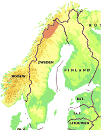
Zweeds Lapland (Lappland, Lapponia) wordt wel een de laatste wildernis van Europa genoemd. Feitelijk is het een cultuurlandschap, al duizenden jaren bewoond door de Samen die er hun rendieren laten grazen. Dat neemt niet weg dat het berggebied (fjällen) spectaculair en van een wondermooie schoonheid is.
Het gebied kent zeven nationale parken. Een aantal van deze vormen samen het werelderfgoed Lapponia.
Zweeds Lapland biedt uitgebreide mogelijkheden voor meerdaagse wandelingen. Voor wie dat wenst is ook een uitgebreid netwerk van berghutten beschikbaar.
Zie verder:
Norrbottensfjällen (van de provincie Norrbotten). Deze site bevat ook actuele informatie over het berggebied
overzicht met vertrektijden bootverbindingen
Sverigeturism beschrijft op haar website beschrijft op haar site Zweeds Lapland als volgt:
Sweden's most northerly provinces Västerbotten and Norrbotten consist of approximately 1/3th of the total area of Sweden and are full of contrast; sea, coast, forests and mountains are all found here. These provinces are full of opportunities for recreation and leisure in the wilderness. You have all the large parks and national reserves with unspoiled nature to explore. The provinces are also of vital interest in the development of Swedish industry and welfare because of the rich supply of natural resources.
More than half of the mountains in Sweden are in these provinces.They are made for the nature-lovers. The mountain regions in these provinces provide lots of opportunities to experience interesting flora and fauna in their natural habitats.
While the mountains attract most people and have the most dramatic sceneries, the coastal area with its extensive archipelago has stood in their shadow. Now however, many tourists are discovering the charm of the coastal towns and the archipelago.
In Sweden, most of the country's rivers and falls have been harnessed to provide electricity power. Four of the remaining rivers are still free to seek their own course from the mountains to the shore and they are the Vindel-, Pite-, Kalix- and Torne Rivers. All four provide great opportunities for fishing and rafting during the summer season.
While the natural resources in the provinces makes it a paradise for nature and wildlife-lovers, the provinces as well have a developed and varied industry. Mining dominates the industrial production but other industries are steadily growing. Especially in the communications and service sectors.
Norrbotten kent een uitgebreide netwerk van wandelpaden.
Zie hieronder en de tab nationael parken voor aanvullende informatie. (zoals Muddusleden - 44km- door nationaal park Muddus)
Enkele netwerken:
Het netwerk van wandelpaden in de Arjeplogsfjällen (270 km)
Het netwerk van wandelpaden in de Abisko-Kebnekaisefjällen (820 km)
In Västerbotten bevinden zich de volgende wandelpaden:
- Het netwerk van wandelpaden in Vilhelminafjällen (420 km)
- Het netwerk van wandelpaden in Vindelfjällen (520 km)
- Isälvsleden (60 km)
Råstofjällen
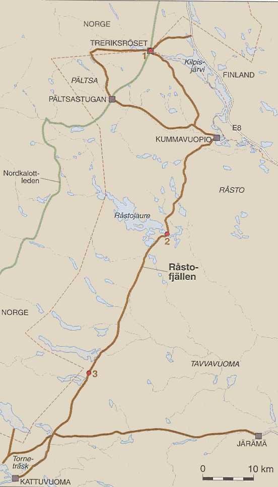
Råstofjällen (237 km) - in de noordoostpunt van Zweden; - het pad loopt van Treriksröset - het drielandenpunt naar Kattuvuoma, of omgekeerd
Råstofjällen is het gebied in het meest Noord-Westelijke hoek van Zweden. Aan de Noordkant wordt het begrensd door de grensrivier met Finland, aan de Westkant door de grens met Noorwegen, en aan de Zuidkant door het meer Törneträsk en de rivier Torneälven. Aan de oostkant vormt de weg van Karesuando naar Soppero (Kiruna) de begrenzing.
Het is een weinig bezocht gebied dat wordt gebruikt door Esrange, het European Space Range. Esrange is een internationaal centrum voor ruimte operaties d.m.v. satelieten, raketten, ballonnen etc. Bij lanceringen vallen (resten van) deze ruimtevaartuigen terug in het gebied, dat op de kaart staat aangegeven als "Raketskjutfält" of "Skytefelt for raketter". Het gebied is vrij toegankelijk behalve als er lanceringen zijn gepland. Op de website van Esrange of bij het Toeristenbureau in Kiruna is het lanceerprogramma verkrijgbaar. Tijdens lanceringen word je geacht te schuilen in de schuilruimtes die hier en daar zijn neergezet.
Er zijn vrijwel geen voorzieningen in het gebied. Wel is er een enkele gemarkeerde route uitgezet (die met name als skiroute in de winterperiode gebruikt wordt).
Aan de Noordzijde is Råstofjällen bereikbaar
- via Kilpisjärvi (Treriksröset) waarbij je het wandelpad naar Pältsastugan kunt gebruiken (onderdeel van de Nordkalotroute). Vanaf hier kun je het gemarkeerde wandelpad Råstofjällen volgen.
- via de brug over de grensrivier bij Peera, een berghotel langs de E8. Aan de Zweedse kant ligt de nederzetting Keinovuopio. Vanaf hier start een karrenspoor (ATV-pad) naar Pulsujärvi (tussen Vutnusjärvi en Rusuvárri ontbreekt het pad vrijwel en is het terrein door kniehoge dwergberken moeizaam
beloopbaar, ervaring 2002). Het pad kruist de de rivier Lainioälven. Ik weet niet of de rivier goed doorwaadbaar is (ik heb het pad 8 km voor de rivier verlaten en ben vandaar oostwaarts gelopen).
Kilpisjärvi en Peera zijn te bereiken met het openbaar vervoer:
Route1: Kiruna-Karesuando-hotel-1 km lopen naar Finland, bij benzinestation bus naar Kilpisjärvi;
Route 2: dagelijkse busdienst van Rovaniemi naar Kilpisjärvi).
Aan de zuidzijde is het gebied zomers niet toegankelijk zonder boot of helikopter. De Torneälven vormt een onneembare barriëre. Vermoedelijk is vervoer te regelen bij Kiruna flyg.
Je kunt ook vanuit Björkliden nabij Abisko om het meer Torneträsk lopen en via het gebergte aan de noordkant naar Kattuvuoma of naar Vuoskojaure lopen. Vanaf hier kun je het wandelpad naar Kilpisjärvi volgen. Dit is de variant die ik in 2002 heb gelopen. Björkliden is dagelijks met de trein
vanuit Kiruna of Narvik bereikbaar.
Aan de Oostzijde is het gebied bereikbaar via een weg ten Noorden van Övre Soppero. Deze weg gaat naar Järamä en Pulsujärvi, nederzettingen van de Samen. Je kunt ook starten vanuit Maunu, een gehucht iets ten westen van Karesuando. Hier begint een karrenspoor, nou ja, een door atv's of quad's ingeslepen pad.
Het wandelpad Råstofjällen loopt van Kattuvuoma (even ten Noorden van het meer Törneträsk via Råstojaure (een meer beroemd om zijn vis met een viskamp) en de Pältsastugan (aansluiting op Nordkalottleden) naar Treriksröset (het drielandenpunt). Daar waar de Nordkalottleden door het Dividal in Noorwegen voert, neemt het pad Råstofjällen een oostelijker route aan de Zweedse kant van de grens. Er zijn onderweg geen voorzieningen (m.u.v. Pältsastuga aan het eind van de route), loopt over relatief licht terrein en kent weinig bezoekers.
In 2002 heb ik het pad gelopen van Kilpisjärvi naar Vuoskojaure en vandaar cross country (d.w.z. padloos) naar Björkliden. Dit laatste stuk is wat zwaarder dan het uitgezette pad maar goed te doen.
Verder kun je ook cross country door Råstofjällen trekken. In 2005 ben ik vanaf de brug over de grensrivier bij Peera naar Karesuando (Maunu) gelopen. Aan begin en einde van de tocht kon ik een karrenspoor volgen, de rest was cross country. De vegetatie stond hierbij danig in de weg, hetgeen resulteerde in een zeer zware trektocht. De struiken van dwergberken kunnen dicht op elkaar staan en tot kniehoogte reiken. Bij beekjes belemmeren stroken manshoge wilgenstruiken (Salix lapponum en Salix glauca) de doorgang.
Nordkalottleden
Nordkalottleden (van Kvikkjokk/Sulitjelma naar Kautokeino) - zie de aparte pagina Nordkalottleden (800 km waarvan 350 km in Zweden)
Kungsleden
Kungsleden (van Hemavan naar Abisko) - zie de aparte pagina Kungsleden (440 km)
Padjelantaleden
De STF beschrijft het pad als volgt "Experience the rounded mountains, heaths and large lakes that are often described as giving the greeny-blue landscape a contemplative atmosphere. This is where the 160-kilometre-long Padjelantaleden trail runs, a trail that will suit walkers of all levels, even the less experienced. The trail through Padjelanta National Park begins and ends in Kvikkjokk and Ritsem, which are located outside the park itself."
Zie verder de website van de STF Padjelantaleden
De website van Distant North geeft meer informatie me o.a. kaartje Distant North
Eigen wandelroutes Lappland (Zweden)
Sveg-Valadalen 1986
115 + 90 + 135 kmHellagsfjället/Blahammarfjället/Brunnerfjällen
Ga naar Kaart
Hemavan-Graddis -- Sulitjelma-Kvikkjokk 1988
175 + 110 kmN. Storfajallet - Vindelfjallen (np) - Ammarfjället
Ga naar Kaart
Riksgränsen-Ritsem-Sulitjelma-Kvikkjokk 1990
100 + 100 + 90 kmPadjelanta (np)
Ga naar Kaart
Storlien-Snasa-Gaddede-Borgafjal 1992
165 + 105 + 95 kmSkjekarfjället - Gressamoen (np) -Borgafjallen
Ga naar Kaart
Kilpisjärvi - Björkliden -- Abisko - Abisko 2002
200 + 100 kmGemeente Kiruna: Råstofjällen, Abiskofjällen
Ga naar Kaart
Ga naar Fotoalbum
Gäddede - Klimpfjäll 2004
100 kmGa naar Kaart
Abisko - Ritsem 2017
110 kmNationaal Parken Abisko en Sjöfjallet
Deeltraject 2 van de Sentimental Journey 2017
Nordkalottleden en eigen route
(deels) herhaling deel van de trektochten 1989 en 1990
Bus Ritsem - Gälllivare / trein Gälllivare - Björkliden / bus Björkliden- Karesuando / bus Karesuvanto - Kilpisjärvi
Ga naar Kaart
Ga naar Fotoalbum
Kilpisjärvi - Kilpisjärvi 2017
55 kmDrielandenpunt
Deeltraject 3 van Sentimental Jurney 2017
- deels Nordkalottleden
- klein stukje trektochten 1995 en 2002
Bus Kilpisjärvi - Enontekio
Ga naar Kaart
Ga naar Fotoalbum
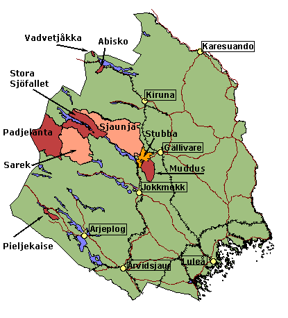
De Unesco heeft een deel van Noord-Zweden aangewezen als werelderfgoed. Het omvat de vier nationale parken Muddus, Sarek, Padjelanta, and Stora Sjöfallet en de natuurreservaten Sjaunja en Stubba alsmede de gebieden Sulitelma, Tjuoltadalen, and Rapadalen.
"The Laponian area is Europe's largest continuous area of virtually untouched nature. It has steep mountain massifs and extensive mountain plains, glaciers, mires, and primeval forests, torrential waterfalls and large mountain lakes. In addition, it has a rich animal and plant life, with several endangered species.
Laponia is the cultural landscape of the Saami people and one of the last large wildernesses of Western Europe.The whole area comprises 9,400 square kilometres of great geological, ecological, and cultural value with magnificent scenery."(bron: Riksantikvarieämbetet)
Sites:
- Unesco world heritage
- Lapplands världsarv
- Focus Lapponia, de officiele website met plaatjes en animaties
- www.laponia.nu
Nationale parken
The oldest and largest national parks in Sweden are to be found in Norrbotten. Eight of Sweden's twenty-six national parks are located here. With the exception of Muddus and the Haparanda archipelago, the national parks in the province are in the mountain region. Together they cover over 6000 km², which means that the national parks in Norrbotten count for 95 % of the area dedicated to national parks in Sweden. The parks in the mountain region comprise 5500 km². Swedish laws protect their natural environment. parken
Visit the Parks
The rapidly changing weather and the steep topography make visiting the mountain areas a challenge. The national parks are large wilderness areas as well, and haven't been adapted much for visitors.
People without much experience in the mountains can, nonetheless, visit parts of Abisko and Stora Sjöfallet. Throughout these national parks there are actually roads and even small tourist localities with mountain hotels inside the parks. These tourist facilities are good points of departure for day outings in the surrounding national park area. Marked hiking trails such as Kungsleden make hiking less difficult in Abisko and Stora Sjöfallet.
Likewise Muddus can be reached easily for day excursions from connecting roads at the border of the park. In Muddus, if one wants to cover all the things worth seeing, it would be good to plan a hike of several days duration along the trail that has cabins in four different locations where one can spend the night.
The smaller mountains parks of Vadvetjåkka and Pieljekaise are farther away from the nearest road, and it will take at least two days to visit them.
The national park complex of Padjelanta, Sarek and the western part of Stora Sjöfallet is more demanding for the visitors than the other parks. Sarek and the adjacent part of Stora Sjöfallet is a difficult area. It lacks trails and presents an almost impassable terrain, being subject to frequent rains.
This national park area should only be visited by people who are well-experienced mountain hikers.
The terrain in Padjelanta is not as extreme as in Sarek but it is rainy even there. A hiking trail with cabins to spend the night makes it a more appropriate area for less experienced mountain hikers.
(Bron: Naturvårdsverkets Sveriges Nationalparker)
Abisko
Abisko National Park is a classic region in the heart of Lapland?s alpine world.
Majestic mountains frame the beautiful Abiskodalen valley with its flowering alpine meadows, picturesque rapids and Scandinavia?s largest alpine lake. During the summer you can experience light day and night and see the midnight sun.
Abisko National Park measures 7,700 hectares and is south of Torneträsk lake in Kiruna municipality. You will find the Abiskodalen valley here, covered with mountain birch trees, and beautiful and easily accessible Mount Njullá, known for its profusion of flowers. The Abiskojåkka river flows through the long valley, and close to the tourist station and naturum Abisko visitor centre, it rushes forward through a beautiful canyon. Kungsleden (the King?s Trail) and several other trails and nature paths traverse the park.
Abisko National Park is on mountain bedrock with veins of limestone. Inland ice sheets formed the large alpine valley located in the park. The Abiskojåkka river flows through the long valley to ultimately rush along in a canyon flanked by steep cliffs of hard schist and dolomite limestone. (bron Naturvårdsverket, 2022)
Naturvårdsverket: AbiskoBjörnlandet
Björnlandet ligt in de provincie Västerbotten.
Björnlandet National Park is a beautiful primeval forest
Björnlandet is in Åsele Sami country ? a magnificent wilderness and one of Sweden?s most valuable primeval forests.
Nestled in Swedish Lapland is Åsele ? a grand wilderness and one of Sweden?s most valuable virgin forests.
Stunning, ancient pines, lichen draping over the coniferous swamps and the evident traces of forest fires make Björnlandet a living, dynamic ecosystem and a biological historical archive showing us the dramatic events of times past.
Björnlandet national park was founded in 1991. It spans 2,300 hectares of forest preserved for future descendants. The forests remain similar to the natural environments described by Linnaeus following his journey to Lapland over 280 years ago, and consist mainly of ancient pines. Most trees are around 180 years old, but there are other trees that are much older.
Here, you will also find traces of previous forest fires. The charred stumps and damage to living pines left behind by the heat of the flames are a regular sight throughout the park. The last major fire raged in 1831 ? a year that was one of the worst years for forest fires in Norrland. We have not found any traces of human settlements in this area, but we have found evidence of logging and log driving. The park is also used for reindeer husbandry.
Because of its harsh inland climate, the diversity of flora is relatively poor. However, with any luck you might see a Lapland buttercup tucked away amongst some of the undisturbed coniferous swamps in the park.
You cannot escape the hills, rocks and stones of Björnlandet national park. Steep slopes, vast swathes of rocks and massive stones give the forest its character. The terrain has been difficult to navigate since the most recent ice age.
The area?s bedrock consists of red-grey Revsund granite. This rock is typical of the inland areas of southern Lapland and Jämtland and creates nutrient-poor moraines. The rock itself is coarse-grained. It weathers easily and contains potassium feldspar crystals up to 10 cm in size. The rock is estimated to be around 1,800 million years old.
The sunken rocks were formed during one of the ice ages, when the movement of ice broke off many mountain peaks and deposited them along the way. This is sometimes referred to as flow-till. Subsequent frost weathering has raised and lowered rocks and stones. Carpets of lichen, knotted pines and the occasional rodent or bat make themselves at home amongst the sea of rocks.
The peak of Storberget fell is 551 m above sea level, and is the highest point amid a massif that includes Jon-Esberget and Björnberget fells. There are many mighty slopes and precipices around these fells and Häggsjöberget. Occasionally, you will find incredibly old pine trees around these hard-to-reach areas. Often, close to the precipices there are areas with giant rocks that sometimes create rock caves. (bron Naturvårdsverket, 2022)
Naturvårdsverket: BjörnlandetMuddus / Muttos
Muddus / Muttos National Park is a land of forests and vast marshes
Here you will find intact primeval forests with giant long-boled pines, enormous mosaics of marshland, waterfalls and deep canyons. Experience the silence of the primeval forest and wildlife that is typical for Norrland?s nature ? where it is left in peace.
Muddus/Muttos is Sweden´s largest forest nationalpark. Muttos is part of Laponia, a Unesco World Heritage Site.
Hiking trail makes it easy to explore large parts of the national park. There also are paths that follow ancient migratory routes, passing by five cabins with sleeping accommodations that are open year-round.
In the national park you can also see remnants of settlements that were here about 100 years ago.
In the south the national park slopes down towards the Luleälven river and the elevation drops by 200 metres in just 10 kilometres. The Muttosädno river conveys water away from the large marshes via the renowned Muttos waterfall. Farther to the east is Måskosgårsså, a box canyon that looks like a notch in the middle of nature.
Muddus/Muttos National Park is one of the quietest places in Sweden. Researchers who have measured the sound level have shown that this and similar primeval forest areas are quieter than all other kinds of nature.
Muttos is part of Laponia, a Unesco World Heritage Site. In 1996 Muttos became a part of the Laponia World Heritage. It also inlcudes the national parks Sare, Stora Sjöfallet/Stuor Muorkke and Padjelanta/Badjelánnda, together with Stubbá and Sjávnja natures reserves, among other smaller areas. (bron Naturvårdsverket, 2022)
Naturvårdsverket: MuddusPadjelanta / Badjelánnda
Padjelanta / Badjelánnda National Park is a floral paradise and grazing land for the reindeer
Padjelanta ? Badjelánnda in the Sami language ? is an alpine landscape of sweeping high plains and large lakes. The terrain is open, with soft contours, in contrast to the adjoining Sarek mountains. In Padjelanta/Badjelánnda you will come in contact with some of the mountains? most luxuriant flowering meadows as well as most of the bird species associated with the heaths and lakes of the barren heights.
The camps of the Sami reindeer husbandry groups line the large lakes. The reindeer have their summer grazing land in the national park. If you are lucky, you will be able to see some of the Sami residents gather for branding of reindeer calves during the luminous nights. Nowadays they use helicopters and motorcycles.
Padjelanta/Badjelánnda is Sweden?s largest national park. In Sami the name means ?highland?. Rounded mountains and large lakes are surrounded by a backdrop of snow-clad mountains: Sarek in the east and Sulidälbmá in the west, along with the Norwegian border mountains.
Padjelanta/Badjelánnda is part of Laponia, a Unesco World Heritage Site. In 1996 Padjelanta/Badjelánnda became a part of the Laponia World Heritage. It also inlcudes the national parks Sarek, Stora Sjöfallet/Stuor Muorkke and Padjelanta/Badjelánnda, together with Stubbá and Sjávnja natures reserves, among other smaller areas. (bron Naturvårdsverket, 2022)
Pieljekaise
Pieljekaise National Park - The national park of mountain birches
Pieljekaise National Park, with its untouched, vast birch forests, lies off the beaten track. Its forests connect the mountain valleys with the bare mountain heights above the tree line. It is a place of refuge for birds and beasts of prey, but also a place from time immemorial for Sami reindeer husbandry.
Pieljekaise National Park is in the Arjeplog mountains between Jäckvik and Adolfström.
The highest mountain, with a summit 1,138 metres above sea level, is Pieljekaise, which also gave the national park its name. In Sami the mountain is called Bieljijgájse, which means ?ear mountain?. The two peaks of the mountain look like an ear in profile. The national park is in a low mountain area with many small lakes and birch forests, but also heaths and meadows with abundant flora. The aim of the national park is to preserve an area with mountain birch forests in its natural state. Pieljekaise National Park is in the Semisjaur-Njarg sameby, a Sami economic and administrative unit created with the intention of tending reindeer.
On the road from Arjeplog to Jäckvik or Adolfström, the first half of your trip is over primitive rock that is nearly two billion years old.
After that, you come to the mountain range?s youngest bedrock ? rock that is only 400 million years old. During the millions of years that have passed since the bedrock formed, it has been worn down to the mountain range we see today.
Pieljekaise?s rounded mountains and long valleys are composed entirely of mountain bedrock with meagre, hard types of mountain rock that decomposes slowly. As a result, the vegetation also is meagre. Below the tree line a sparse heath birch forest grows, and above the tree line you can hike across alpine heath with crowberries, mountain bearberries and dwarf birch trees. The more lush meadow birch forest grows where the lower part of the mountain bedrock?s schist has decomposed and created fertile soil down in the valleys.
Traces of the time when Scandinavia was covered with ice are visible in the national park. About 9,000 years ago, the ice in the mountains melted away. Among the things that remained are the long, rounded U-shaped valleys chiselled out by the ice. Also left behind are many large, easily visible boulders that had once been embedded in the ice. (bron Naturvårdsverket, 2022)
Sarek
Sarek National Park is the most dramatic and grandiose of all.
Mountains higher than 2,000 metres and almost 100 glaciers. Long, deep, narrow valleys and wild, turbulent waters. A tortuous delta landscape. A high alpine area where the Sami people have lived from time immemorial. Completely lacking in comfortable accommodations. This is where visitors and the wild World Heritage Site meet.
Sarek is the national park with six of Sweden?s thirteen highest mountains and almost 100 glaciers. It is a high alpine area where the Sami people have lived from time immemorial. The valleys and the mountain slopes are grazing land for three Sami communal groups engaged in reindeer husbandry: the Sirges, Jåhkågaska tjiellde and Tuorpon.
The national park also is known for its wildlife, including large elk and many predators. Meltwater from the many glaciers flows into Sarek?s artery, the Ráhpaaädno river, which creates the alpine world?s most well-known delta. The area bears the stamp of the inland ice sheet, and a hike through Sarek is a trip through Sweden?s geological history.
Glaciers carved out Sarek and made it what it is today. They scraped away at the land to create the sharp ridges and peaks in Sarek. Their continuous movement produces rock dust that is then carried away by the meltwater. Without glaciers in Sarek, the well-known Ráhpaäno Suorgudahka, the Rapaätno river delta, would not exist. The ice sheet also has sculpted the large valleys, widening and rounding them off. Njoatsosvágge in Sarek is an example of such a classic U-valley where the ice sheet has rounded the contours. The reason the landscape is so striking is because of the amphibolite bedrock, which resists erosion especially well.
Sarek is one of Sweden's most inaccessible national parks for anyone who cannot hike or ski in on their own. There are no roads leading up to the national park. (bron Naturvårdsverket, 2022)
Naturvårdsverket: SarekStora Sjöfallet / Stuor Muorkke
Stora Sjöfallet / Stuor Muorkke National Park
Alpine nature in the high Nordic region
Imposing mountain ridges, deep sculpted valleys, high boulder fields and beautiful pine primeval forests. The mountain celebrated in the Swedish children?s classic about Nils Holgersson is here: the Akka massif, also known as ?the Queen of Lapland?.
Five majestic waterfalls cascaded over the brink and roared down into Lake Lá?as. Hence the name Stora Sjöfallet, which means great waterfall in Swedish, or Stuor Muorkke, the Sami name given to the park when it was formed in 1909. That name refers to a large ?mårka?, that is land between two lakes. The national park was formed to protect the waterfall and its source lakes. Shortly after the park?s formation, its map was redrawn to generate hydroelectric power. The waterfall known as Stuormuorkkegårttje in the Sami language remains, but it is not as majestic as it once was.
The national park lies off both sides of the dam-regulated Áhkkájávrre reservoir. It is a varied national park with alpine mountains, glacial mountain heaths, mountain birch slopes and stately primeval pine forests. The boundary in the north is the deep Dievssávágge, regarded as the most beautiful valley in Sweden. Rising in the south is the majestic Áhkká massif and its glaciers. It is visible from almost anywhere you happen to be in the national park.
This area is grazing land for the Sami villages of Sirges and Unna Tjerusj, which have their settlements all around the area. A Sami village (?sameby? in Swedish) is not a village in the usual sense, but rather an economic and administrative unit engaged in reindeer husbandry. In the summer the herds graze in mountain valleys all the way to the Norwegian border. The road into Stora Sjöfallet/Stuor Muorkke makes the park easily accessible for visitors.
"The lake was the road before; it was the communication route. The north side was rather sparsely settled. It was blustery, not so attractive. The south side was Stuor Muorkke?s heart, where you came with the boats. When the road came, people moved to the side of the road. We were flexible and we moved to follow the fishing.?
In the east the national park boundary lies right next to what is called the ?glint?. The glint is a distinct dividing line between flat primitive rock and the more dramatic mountain bedrock. By Mount Giergav in Sáltoluokta, the glint is very obvious. The steep mountainsides show how the new mountains rose up above the primitive rock. They have eroded and been ground down over the years, but the dividing line is clearly visible in the terrain.
South of Giergav is a Sami settlement by Lake Bietsávrre. It is in a deep U-shaped valley that once was formed by the inland ice sheet. Lake Bietsávrre is at the end of the huge outwash plain that begins nine kilometres up in the valley. It demonstrates how ice rivers from the melting, retreating inland ice sheet carried with them enormous quantities of sand to build up a sandy plain with a network of water furrows that are completely dry today. One hundred metres of loose earth lies on top of the bedrock, the greatest depth of earth measured in Norrland.
The Áhkká massif, several miles away, is an example of dark, hard amphibolite, a type of rock that has resisted the wear and tear of the Ice Age. Southwest of Áhkká there are clear traces of the latest inland ice sheets. When the inland ice melted, it created ice lakes and ice rivers, which in turn formed the delta. Today it appears in the form of terraces, both below Áhkká and in the vicinity of the Gisuris cottages. (bron Naturvårdsverket, 2022)
Naturvårdsverket: Stora SjöfalletsVadvetjåkka
In the roadless land by Sweden?s border with Norway lies Vadvetjåkka National Park ? a desolate corner of northern Sweden. Come here if you want to experience profound solitude, an abundance of alpine flora and a system of deep caves.
Reindeer husbandry has been carried out in Vadvetjåkka for centuries. The national park is an important part of the summer grazing land for the Talma sameby, a Sami economic and administrative unit. In the delta Sami settlers harvested sedge in the 1940s.
South of the mountain there is a large delta area with a large bird population as well as lakes, thickets of willows and marshes. The national park is made up predominantly of bare mountain areas above the tree line. The climate in Vadvetjåkka National Park is affected by its location close to the Atlantic, and the weather often is cloudy, with large amounts of precipitation.
Vadvetjåkka National Park consists of its namesake mountain and the adjacent delta. Sweden?s northernmost glacier is here. In the park and just west of it, there also are some of the country?s deepest limestone caves, which were formed by flowing subterranean water. (bron Naturvårdsverket, 2022)
Naturvårdsverket: VadvetjåkkaAgemeen:
- Portaal Norrbotten direkt
- Portaal Västerbotten Direkt
- Provincie Norrbotten (länsstyrelsen)
- Provincie Västerbotten
- Toerisme provincie Västerbotten
- IT adventure met veel toeristische informatie w.o. campings, dienstroosters etc
De toeristenpagina's van de gemeentelijke sites Norrbotten:
- Arjeplog
- Arvidsjaur
- Boden
- Gällivare
- Haparanda
- Jokkmokk
- Kalix
- Kiruna
- Luleå
- Pajala
- Piteå
- Älvsbyn
- Överkalix
- Övertorneå
Gemeentes in de provincie Västerbotten

- Bjurholm
- Dorotea
- Lycksele
- Nordmaling
- Norsjö
- Malå
- Robertsfors
- Skellefteå
- Sorsele
- Storuman
- Umeå
- Vilhelmina
- Vindeln
- Vännäs
- Åsele
Het weer
- Institutet för rymdfysik (IRF) (Zweedse Instituut voor Ruimte fysica heeft een goede weerpagina met het weer in Kiruna (hoog-laag temperatuur vandaag en afgelopen 7 dagen, historische database).
- Sveriges Television (SVT) geeft een weerprognose voor de meeste steden van het land.
- SVT Kiruna. Ook met videopresentatie van het weer in Zweden.
- De Zweedse KNMI: SMHI