start > wandelsite > Lapin lääni
Lapin lääni
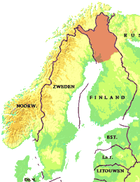
Fins Lapland is een heerlijk wandelgebied voor wie de rust, stilte en de beschutting van de Taiga zoekt.
Anders dan in Zweden en Noorwegen ligt Fins Lapland vrijwel geheel onder de boomgrens. Slechts kleine gebieden, de Tunturi, steken boven de boomgrens uit. Dit geeft Fins Lapland een geheel eigen karakter.
Fins Lapland kent vijf nationale parken waarvan er twee zeer uitgestrekt zijn: Urho Kekkonen aan de grens met Rusland en Lemmenjoki dat aan Noorwegen grenst.
De parken zijn vrij toegankelijk en uitstekend geschikt voor (lange) wandeltochten. Buiten de kerngebieden mag je in de zogenoemde wildernisgebieden vrij wandelen en kamperen, daarbinnen zijn bepaalde kampeerplaatsen ingericht die op de kaarten staan ingetekend.
De wildernisgebieden bieden uitstekend mogelijkheden om langere trektochten te maken. Soms lopen er gemarkeerde wandelpaden doorheen maar lang niet altijd is dat het geval. Goede ervaring met het werken met kaart en kompas is daarom vereist. Er zijn vaak wel ongemarkeerde paden en her en der liggen wildernishutten waar je kunt overnachten. Het Finse staatsbosbeheer zegt er het volgende over:
"The wilderness is an ideal environment for the experienced trekker who wants to enjoy the peace and solitude of the wilderness and choose his or her own trails without the danger of bumbing into other hikers. When doing so,one must have such orienteering and hiking skills that one is able to manage even in the most difficult weather conditions. One must also be properly equipped with a sleeping bag and a tent. There are only a few wilderness huts or marked trails in some of the wilderness areas.
When you head for the Lappish wilderness, you should bear in mind that in case of an accident it may take a long time before you get help."
Hieronder vind je een overzicht met de wildernisgebieden (geel op het kaartje, bruingekleurd zijn de natuurreservaten en de nationale parken zijn lichtgroen)
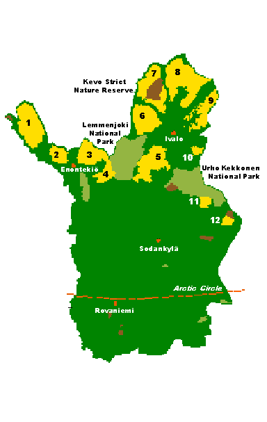
- Käsivarsi
19 wilderness huts and 5 reservable huts, Arctic Trail - Tarvantovaara
2 wilderness huts, Vanha postipolku trail, River Lätäseno canoe route, snowmobile trail Hetta - Kilpisjärvi - Pöyrisjärvi
6 wilderness huts and 1 reservable hut, River Käkkälöjoki canoe route, marked trail Hetta - Näkkälä - Pulju
3 wilderness huts, no marked trails - Hammastunturi
6 wilderness huts, River Ivalojoki canoe route, snowmobile trail Ivalo - Hammasjärvi - Inari - Muotkatunturi
2 wilderness huts, snowmobile trail Inari - Karigasniemi - Paistunturi
3 + 1 wilderness huts, Kevo Trail, Utsjoki hiking trail - Kaldoaivi
6 wilderness huts, Sevetti - Pulmanki trail for hikers and snowmobilers - Vätsäri
3 wilderness huts, no marked trails, snowmobile trails Ivalo - Sevettijärvi and Nellim - Sevettijärvi - Tsarmitunturi
no wilderness huts, no marked trails - Kemihaara
1 wilderness hut, no marked trails - Tuntsa
2 wilderness huts, UKK Trail
De natuurreservaten zijn veelal niet toegankelijk voor publiek. Van de 8 natuurreservaten in Fins Lapland zijn er drie beperkt open voor publiek:
- Kevo
- Sompio
- Malla
Door deze reservaten loopt een wandelpad. Je mag niet van dit pad afwijken. het Finse staatsbosbeheer zegt er het volgende over:
"Strict nature reserves have been established for scientific reasons. They primarily serve the needs of nature conservation and research as well as, within certain limits, instruction. For studying changes in nature, they
also act as control areas.
The regulations applying to strict nature reserves are stricter than those in the national parks. It is generally not possible to move around in them without a written permit. Some strict nature reserves have a nature trail
open to the public. Permission to visit places off the hiking trails is given only for scientific purposes."
Zie verder ook de informatie van het staatsbosbeheer:
Twee grote wandelpaden in Fins Lapland zijn de E6 en de E10 die ieder weer bestaan uit lokale paden.
De nationale parken en wildernisgebieden kennen vaak ook uitgezette routes (te vinden op de topografische kaarten)
UKK-reitti (E6 en E10)
Twee grote wandelpaden in Fins Lapland zijn de E6 en de E10 die ieder weer bestaan uit lokale paden.
Noord-Oost Lapland: De E10 (van Gibraltar naar de Barentszee) loopt van Helsinki naar Joensuu en komt via het nationale park Oulanka Fins Lapland binnen. Vandaar via de UKK-reitti naar het nationaal park Urho Kekkonen. Door het park naar Saariselkä. Met de bus via Ivalo en Inari naar Setesjarvi. Vandaar door het wildernisgebied Kaldoaivi naar Karigasniemi aan de Fins-Noorse grens. Het traject vandaar af is cross country naar Gamvik, ongeveer het meest noordelijke puntje van Noorwegen (op de op een eiland liggende Noordkaap na).
Noord-West Lapland: De E6 (van Griekenland naar het drielandenpunt bij Kilpisjarvi) loopt van Stockholm-Turku naar Oulu en komt via Kemi Fins Lapland binnen. Vandaar naar het nationaal park Pallas-Ounastunturi. Via Enontekio naar de Fins-Noorse grens. Cross country naar Kautokeino en vandaar kan de Nordkalottenroute (Arctic trail) gevolgd worden via nationaal park Reisa naar Kilpisjarvi.
Urho Kaleva Kekkonen Trail
De UKK-reitti is onderdeel van de Europese Lange Afstands Wandelpad E6
Er is weinig informatie beschikbaar.
Enig informatie is te vinden op Traildino.com
Het traject dat ik in 2000 zo ongeveer heb gelopen gaat als volgt:
Startpunt is Ruka (even ten noorden van Kuusamo) - via het berenpad (Karhunkierros) door het Oulanka nationaal park - langs Hautajarvi de UKK-reitti volgend naar Salla. Zonodig even inkopen doen en bijtanken in Kemijärvi. Daarna met de bus tot Saija. Via de UKK-reitti door het wildernisgebied van Tuntsa naar Kulppio. Cross country door het wildernisgebied Kemihaara en verder door het nationaal park Urho Kekkonen. Eindpunt is Saariselkä aan de noordwest kant van het park. In dit toeristendorp vind je winkels, hotels en goede busverbindingen naar Ivalo of Rovaniemi.
Vanaf Saariselkä kun je verder wandelen door de wildernis van Hammastunturi(ongemarkeerde routes). Dit gebied sluit aan op het nationaal park Lemmenjoki dat op zijn beurt weer een geheel vormt met het in Noorwegen gelegen nationale park Övre Annarjokka. Via dit gebied kun je naar Kautokeino lopen. Kautokeino is het eindpunt van de Nordkalottroute.
Inari trail
Rondom Inari zijn diverse (kortere) wandelpaden aangelegd.
Zelf liep ik in 2011 van Kakslautanen via Hammastunturi naar Inari. Het laatste stuk was een gemarkeerde route.
Zie ook nationalparks.fi.
Karhunkierros trail
Nationalparks.fi prijst het pad als volgt aan:
" Finland's most popular hiking trail, the legendary Karhunkierros Trail (also know as The Bear's Trail or The Bear's Ring), takes you to Oulanka's best locations by the roaring waters. The Karhunkierros Trail offers hikers many sights and many sweat-breaking kilometres. Thanks to route alternatives, the trail is also suitable for day trips. Part of the trail is also suitable for canoeing. This trail must be done at least once in lifetime! "
Meer informatie Karhunkierros Trail
Zelf liep ik (een groot deel van) het pad in 2000 (traject Ruka- Salla)
Eigen wandelroutes Lapin lääni
Kilpisjarvi - Kautokeino - Lemmenjoki 1997
180 + 160 kmFinnmark, Fins Lapland: Reisadalen (np)-Övre Anarjokka (np)/Lemmenjoki (np)
In 1997 heb ik het Nordkalottleden nogmaals gevolgd maar nu vanaf Kilpisjärvi naar Kautokeino (180 km) om enkele dagen in het nationaal park Reisa bij de Imofossen te kunnen vertoeven. Vanaf Kautokeino heb ik via Övre Anarjokka een doorsteek naar Lemmenjoki / Inari in Finland gemaakt (160 km).
Deze tocht ging dus door Troms, Finnmark en Lappi Lääni (Fins lapland).
Ga naar Kaart
Ga naar Fotoalbum
Nuorgam-Karigasniemi-Inari -- Raja Joseppi-Sariselkää 1998
170 + 80 + 100 kmFins Lapland: Kaldoaivo-Kevo (np) - Muotkatunturi - Urho Kekkonen (np)
Ga naar Kaart
Ga naar Fotoalbum
Ruka - Salla - Saariselkä 2000
130 + 260 kmFins Lapland: Oulanka (np) - Urho Kekkonen (np)
Berenpad, UKK-reitti
Ga naar Kaart
Ga naar Fotoalbum
Karesuvanto - Kilpisjärvi 2007
200 kmFinnmark / Fins Lapland: stukje Nordkalottleden
Ga naar Kaart
Ga naar Fotoalbum
Kiilopää - Saariselkä 2008
175 kmFins Lapland: Nationaal Park Urho Kekkonen
Ga naar Kaart
Ga naar Fotoalbum
Kakslautanen - Inari / Utsjoki - Karigasniemi 2011
100 + 85 kmFins Lapland: Hamastunturi / Paistunturi
Ga naar Kaart
Ga naar Fotoalbum
Saariselkä - Kiilopää 2017
100 kmNationaal park Urho Kekkonen
Deeltraject 6 van de Sentimental Journey 2017
- deels overlap met trektochten 1998, 2000 en 2008
Bus Kiilopää - Saariselkä / Saariselkä - Inari / Inari - Rovaniemi
Ga naar Kaart
Ga naar Fotoalbum
De beschrijvingen op deze pagina zijn geleend van het Finse Staatsbosbeheer (Metsähallitus). Op hun site vind je aanvullende informatie.
Naast de parken zijn er uitgestrekte wildernisgebieden. Zie de introductie voor een overzicht.
Lemmenjoki
![]()
Inari and Kittilä, 2 855 sq.km. Established 1956, extended 1971 and 1982.
Lemmenjoki is Finland's largest national park. It is also one of Europe's most extensive tracts of roadless, uninhabited forested wilderness. Aside from its value as a nature preserve, the park is also an extremely important area for hiking and reindeer herding.
The park's scenery is characterised by innumerable large rivers and the forest, fell and peatland areas separating them. The central part of the park is dominated by the more than 70 km long River Lemmenjoki and the Maarestatunturi and Viipustunturi fell clusters surrounding it. The northerly location of the park is obvious in its extensive birch forests, which clothe the highest fells and fringe the treeless zones at the summits. However, there is a valuable Scots pine forest nestling in the Lemmenjoki valley. The northern limit of the spruce crosses the southern section of the park. Lemmenjoki's wild character is emphasised by its fairly stable populations of the brown bear and golden eagle.
The recommended starting point for exploring the area is the village of Njurgulahti, near the park's northeastern border on the bank of the River Lemmenjoki. Popular hiking destinations are the Lemmenjoki valley and the Sallivaara area in the southern part of the park. These areas encompass most of the marked trails and other public services. A great deal of the park is extremely wild and suitable for the more demanding kind of hiking. Marked trails are absent, there are few cabins, and the sheer size of the area makes it possible to walk the wild trails for weeks on end.
The most noteworthy sight, the Lemmenjoki valley, is a magnificent section of the river stretching for some 20 km between Njurgulahti and Kultasatama. There is a trail along the river, as well as a regular boat service for visitors. At the confluence of the Lemmenjoki and Ravadasjoki lie the mighty Ravadasköngäs falls.
Other major attractions are Joenkielinen fell, from which a broad vista opens out over the Lemmenjoki valley, the renovated reindeer round-up corral at Sallivaara, and the gold washing areas along the northwestern tributaries of the Lemmenjoki river.
Nationalparks.fi ,met kaarten.Oulanka
![]()
Kuusamo and Salla, 272 sq.km. Established 1956, extended 1982 and 1989.
Oulanka National Park is situated in the Kuusamo Salla upland area. To the east the park is bounded by Russia and Paanajärvi National Park established there in 1992. Objectives of protection are the preservation of a rich variety of land forms and species assemblages, a partly wild area, and various sights, in a natural state, in addition to safeguarding the survival of rare plants in the area. Care is also being taken to preserve the opportunities for natural ecosystem research and monitoring.
Oulanka contains river habitats unique from the standpoint of their landscapes, soil and flora. It includes the River Oulankajoki which drains north into the White Sea, together with the river valleys gouged out by its tributaries, the Kitkanjoki, Savinajoki, Maaninkajoki and Aventojoki. The valleys narrow in places to deep gorges flanked by rugged cliffs. Elsewhere the river beds have become filled with thick layers of gravel through which the river has eventually sliced a high banked channel. In some places the rivers thunder down through some spectacular falls, the most well-known of which are Kiutaköngäs, Taivalköngäs and Jyrävä.
The vegetation of the Oulankajoki river valley has more southerly affinities than that of its surroundings and is much more luxuriant. It includes a number of rarities, notably some eastern and northern species living at the extreme edge of their range. Having been untouched since the turn of the century, the forests provide a good impression of original forest wildlife. Characteristics of the northern sector of the park are extensive peatlands, difficult to cross and of particular importance to the preservation of animal life. Among other species, brown bears inhabit the area. The peatlands form an important nesting ground for whooper swans and other wetland and water birds. A special feature of the riverside are meadows with hay barns established by a bygone culture. Other relics of human civilisations are reindeer fences and the remains of loggers' cabins. Reindeer farming continues to be a thriving occupation within the park.
A network of trails offers abundant opportunities as much for day rambles as for hikes lasting a week or more. The rivers present canoe trippers with a marvellous chance of getting acquainted with the area's wildlife and habitats. Popular beauty spots with visitors are Jyrävä, Kiutaköngäs, Taivalköngäs, in addition to the practical visitor centres; all of these lie alongside the 'Bear's Route', a hiking trail famous throughout Finland. It is only an easy one-kilometre walk from the main visitor centre to Kiutaköngäs falls. Those interested in peatland habitats will do best to follow the fascinating 14 km long Keroharju trail.
Located inside the park there is the University of Oulu biological station. The national park is a constant subject of scientific study. Pesojärvi, to which access is restricted, is an integrated monitoring area incorporated in the ECE's international research network. In this area, the impact of air pollution on the soil, plants and animals is being studied.
Nationalparks.fi ,met kaarten.Pallas-Ounastunturi
![]()
Enontekis, Kittilä och Muonio, 500 kM2. Grundad 1938.
In the EU, forests in the boreal forest zone, also known as taiga, only grow in Finland and Sweden. Pallas-Yllästunturi National Park is internationally extremely important in terms of its natural value. The pristine old growth forests and aapa mires of the park are extremely precious. The sheltering, moist forests offer the only habitat for old growth forest mosses, lichens and fungi. Spruce and pine trees are covered with dark hair lichens, which are also indicators of clean air (i.e. indicator species).
Breathe in the fresh, pure air of Finnish Lapland as you enjoy the literally breath-taking scenery of Pallas-Yllästunturi National Park. This part of Finland has the cleanest air anywhere in the world, according to scientists who have studied air samples taken at a local air quality research station. Breathing pristine, unpolluted air is a rare pleasure today. Most people ? especially those of us who live in cities and towns ? are routinely exposed to a wide range of air pollutants that can cause problems such as asthma and respiratory diseases. Lapland is a great place to give your lungs a detox treat. It's also a region free of noise and light pollution, so you can also enjoy other unforgettable experiences here such as absolute silence and night skies dotted with millions of stars.
Pallas-Yllästunturi National Park's other natural attractions include superb pristine landscapes. Climb up the park's high treeless fells to get fantastic views over Lapland's vast forests and lovely lakes. Because the air is so clean, you can see for miles and miles in every direction, and experience the feeling of being in the heart of Europe's last great wilderness. (bron Nationalparks.fi, 2022)
Nationalparks.fi ,met kaarten.Pyhä-Luosto
![]()
Pelkosenniemi en Kemijärvi, 43 kM2. Gesticht 1938. Uitgebreid 1982
Deep gorges slice through these ancient rugged hills, where you can trek through age-old forests up onto windswept treeless fell-tops. Enjoy Lapland's big skies, lit by the Northern Lights in winter and the Midnight Sun around midsummer. Friendly Siberian jays appear from the woods as if by magic when hikers stop for a picnic. Visit picturesque places that were seen as sacred by the Forest Sámi people who used to live here. Take the epic trail between the park's two most famous fells ? Pyhä and Luosto ? both within reach of comfortable resort centres.
The southernmost area of great fells in Finland offers a versatile glimpse of the northern nature. Pyhä-Luosto National Park is a mosaic of open fell and aapa mires, silent old-growth forests and rugged gorges. (bron Nationalparks.fi, 2022)
Nationalparks.fi ,met kaarten.Urho Kekkonen
![]()
Urho Kekkonen National Park is Finland's second largest in terms of surface area. It extends from the Raututunturit Saariselkä area to the large forests of Savukoski and Nurttijoki. The national park was established to protect forest, peatland and fell ecosystems in the forested (Metsä-Lappi) and southern (Perä-Pohjola) parts of Lapland, and in particular to preserve the preconditions for practicing traditional forms of livelihood, mainly reindeer farming and the tradition of hiking in the wilds.
The northern part of the park consists of a barren wilderness area of fells characterised by ravines, steep slopes and scree. There are comparatively few plant species and the more demanding kinds grow only along streams and rivers. There is plenty of treeless tundra; the fell birch woods are dry and generally have a carpet of lichen. Some variety is brought to the landscape by the Luttojoki and Suomujoki rivers and their tributaries. The park's most renowned sights include these river valleys, Lake Luirojärvi and the highest fell, Sokosti. Good vantage points within easy reach include the summit of Kiilopää, together with Kaunispää outside the national park.
Apart from forests, there are also extensive open aapa bog areas in the southwestern sector of the park. Since these bogs are used by a large number of bird species, visitors are required to avoid the area during the nesting season. Hiking in this sort of boggy terrain is extremely difficult in any case. The southern part of the park consists of a typical forest wilderness, with isolated fells, Scots pine stands and spruce forests where the ground is blanketed with moss. Many of the animal species associated with old forests in a natural state inhabit this area.
Evidence of human history in the region is found in the form of pit traps for wild reindeer, domesticated reindeer round up fences, cabins and restored Koltta Same (Lapp) settlements. Nowadays reindeer herding is the most important occupation in the park and will retain its special status here.
Urho Kekkonen National Park offers excellent opportunities for outdoor activities at all seasons. Long, demanding hikes can be made in the wilder parts, whereas it is easy even for the inexperienced rambler to explore the well marked trails in the much more accessible western area. A popular journey is an approximately week long hike covering the Kiilopää-Suomunruoktu-Tuiskukuru- Luirojärvi-Lankojärvi-Rautulampi-Kiilopää route. In winter there are over 200 km of maintained ski trails in the vicinity of Saariselkä, Kiilopää and Tankavaara. Tankavaara and Savukoski visitor centres, with their appropriate exhibitions and slide shows, form suitable destinations for day- trippers of all ages.
Nationalparks.fi ,met kaarten.Algemeen:
- Algemene site over Fins lapland: www.laplandfinland.com
- Informatie over Inari: www.inarilapland.org
- Informatie Saariselkä: www.saariselka.fi
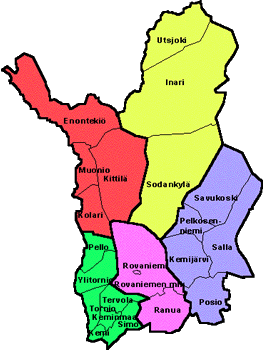
Gemeentes:
- Rovaniemi
- Ranua
- Kemijärvi
- Salla
- Savukoski
- Pelkosenniemi
- Posio
- Sodankylä
- Inari
- Utsjoki
- Enontekio
- Muonio
- Kittilä
- Kolari
- Pello
- Tornio
- Kemi
Parken en wildernisgebieden:
- Salla(site ook in het Engels)
- Saariselkä
- Hammastunturi
- Lemmenjoki
- Övre Annarjokka
Wandelen
- Geweldige site met digitale kaart met alle door staatsbosbeheer erkende wandelroutesExcursionmap.fi