start > wandelsite > Nordland
Nordland
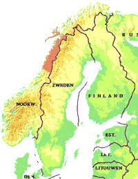
Nordland is de meest zuidelijke provincie van Noord-Noorwegen.
Nordland is ingedeeld in vijf regio's. Van noord naar zuid zijn dat : Vesterålen, Lofoten, Ofoten met de Narvikfjellene, Salten met de Sulitjelmafjellen en de nationale parken Junkerdal en Rago, en Helgeland met de nationale parken Saltfjellet-Svartisen en Børgefjell.
De provincie bestaat voornamelijk uit bergen die steil uit zee oprijzen. Lofoten en Vesterålen zijn in het bijzonder bekend om de ruige bergformaties.
De hoogste bergen (Oksskolten en Suliskongen) zijn in het oosten van de provincie te vinden. Het vasteland wordt door fjorden doorsneden. In Nordland is Noorwegen op zijn smalst: bij Hellemobotn (Tysfjord) is de afstand tussen het eind van het fjord en de grens met Zweden slechts 6,3 km.
Nordland telt een kleine 250.000 inwoners met een oppervlakte dat iets kleiner is dan Nederland. Narvik en Bodø zijn de bekendste steden.
Zie verder wikipedia Nordland
Nordland biedt vele goede wandelmogelijkheden in de nationale parken maar ook in de verschillende fjällgebieden. De verschillende wandelnetwerken zijn aan elkaar gekoppeld via de Nordlandsruta. Aansluitend op de Zweedse Abisko-Kebnekaisefjällen liggen de Narvik fjellen. Dit berggebied kent een netwerk van lokale routes die onderdeel uitmaken van de 550 km lange Nordlandsruta die loopt van Hattfjelldal even ten noorden van Børgefjell in het zuiden naar Bjørnfjell bij Narvik in het noorden.
Nordlandsruta
De Nordlandsroute (550 km), of de ‘vuonagæinno’ zoals de Samen zeggen, loopt van Bjørnfjell bij Narvik in het Noorden tot Børgefjell in Helgeland in het zuiden. Praktisch gesproken door heel Nordland in de lengte. Meer informatie op pagina Nordlandsruta
Narviksfjellen
Aansluitend op de Zweedse Abisko-Kebnekaisefjällen liggen de Narvik fjellen. Dit berggebied kent een netwerk van lokale routes die onderdeel uitmaken van de 550 km lange Nordlandsruta.
De website Taraildino geeft een overzicht van de wandelroutes.
Eigen wandelroutes Nordland
Tärnaby-Majavatn-Saxnäs 1993
160 + 130 kmS. Storfjället - Börgefjell (np) -N. Borgafjällen
In 1993 trok ik vanaf Tärnaby in Zweden door het nationaal park Børgefjell naar het Noorse Majavatn en vandaar weer terug door het park richting Zweden naar Saxnäs.
Ga naar Kaart
Ga naar Fotoalbum
Nordland: Lønsdal - Argaladhytte - Junkerdal 2017
65 kmNationale parken Salten en Junkerdal
Deeltraject 1 van de Sentimental Journey 2017
In 2017 trok ik door het nationaal park Junkerdal richting Sulitjelma. De tocht is afgebroken even ten Noorden van Argaladhytte wegens een te hoge waterstand in het te doorwaden riviertje (er was dat jaar buitensporing veel sneeuw gevallen).
Het plan was een tocht naar Sulitjelma en vervolgens door naar Ritsem. De tocht is een aansluiting op de trektocht van 1988.
Bus Junkerdal - Fauske - Narvik - Björkliden, en vadaaruit start 2e tocht 2017
Ga naar Kaart
Ga naar Fotoalbum
Nordland herbergt vijf nationale parken
Børgefjell
Børgefjell (1447 km2) is het zuidelijkste nationale park van Nordland. De natuur is erg woest, en er zijn geen gemarkeerde wandelpaden. Er zijn maar weinig overnachtingshutten in het park. Børgefjell is vanuit alle richtingen goed te bereiken.
Børgefjell is magnificent. This is where to come for those special up-close experiences with nature and an untouched landscape without being disturbed by others. There are few mountain cabins here and no waymarked trails ? Børgefjell is not a typical tourist area. But if you enjoy visiting interesting areas with a tent and a fishing rod, then Børgefjell is the place for you. The national park has seen virtually no building or construction activity, so you need to be prepared to rely on your own navigation and camping skills.
The park has high peaks, deep valleys, moors, rushing rivers and calm mountain lakes. The area is home to some of the best nature we have to offer in Norway. The landscape bears witness to hundreds of years of Southern Sami domestic reindeer herding, which continues to this day. This is a living cultural landscape. (bron: Norges nasjonalparker, 2022)
website National parksJunkerdal
Junkerdal (682 km2) ligt tussen Sulitjelma in het Noorden en Junkerdal in het Zuiden. In het hart van het park ligt Balvatnet.
Het nationale park Junkerdal heeft als doel om de recreatie te bevorderen. Het park is goed ontsloten door vele wandelpaden en er zijn meerdere overnachtingshutten.
Junkerdal National Park encompasses a large unspoilt mountain area that nevertheless bears witness to considerable human activity. In Sulitjelma, there was mining activity from 1891 to 1991, and the unspoilt mountains were important outdoor recreation areas for weary miners. It was not by chance that there was such an extensive mining industry in ?Sulis?, for the mountains were rich in minerals, such as copper ore and pyrites. The mountains are also extremely calcareous, and in Junkerdal National Park you find a particularly diverse alpine flora. Abutting the national park lies the Junkerdalsura Nature Reserve, which is music to any botanist?s ears. Not only do these calcareous mountains provide a habitat for rare alpine plants, but they also harbour a rich fauna. Moreover, the lakes in the national park are home to fish of a very high quality. The mountains have always been important for the Sami reindeer industry. Both Norwegian and Swedish Sami communities have reindeer herds that graze in the national park.(bron: Norges nasjonalparker, 2022)
website National parksMøysalen
Møysalen (51,2 km2) is een klein nationaal park in een fantastisch berggebied, met markante alpine bergformaties, uitgestrekte groene wouden en open fjorden. Hoog boven in de bergen ligt eeuwige sneeuw en ijs, en er is ook een kleine gletsjer.
---
Møysalen National Park is set in a unique coastal landscape that extends from lush fjordside hillsides and valleys to rocky alpine mountains. Møysalen (1,262 metres above sea level) is the highest mountain in the Vesterålen and Lofoten archipelagos. It is a landmark which has given its name to the national park. There are few visitor amenities in this area, with only a few waymarked trails and no unlocked cabins. This makes certain demands on those who go hiking or skiing in the area, but there are endless opportunities for those who are looking for unique experiences in spectacular scenery.
Møysalen landscape protection area abuts the national park. It encompasses a slightly larger area and complements the protected landscape with fjords, mountains and valleys to the west and south of the national park. (bron: Norges nasjonalparker, 2022)
website National parksRago
Rago (171 km2) is één van de kleinste nationale parken in Noorwegen, maar samen met de Zweedse nationale parken Padjelanta, Sarek en Stora Sjöfallet in Zweden, maakt Rago deel uit van het grootste beschermde ongerepte natuurgebied van Europa. Het landschap van Rago is gevarieerd en is vooral een ruig berg-gebied.
---
In Rago National Park you can enjoy the wilderness of Nordland county, hike through wild, verdant valleys with roaring waterfalls, or luxuriate in the silence of this magnificent alpine setting. Everyone who visits Rago National Park will experience nature at its best, regardless of the season and the weather conditions. Rago is full of contrasts and can offer quiet forests and glacier-scraped mountain formation, rugged cliffs and thundering waterfalls. Rago National Park borders on Sweden?s Padjelanta National Park, which borders in turn on two other Swedish national parks, Sarek and Stora Sjöfallet. Together, these four national parks comprise one of the largest continuous wilderness areas in Europe. These areas are important for the preservation of biological diversity and the safeguarding of natural wetlands. In contrast to the Swedish national parks across the border, Rago has a typical coastal climate with much precipitation, cold summers and relatively warm winters.(bron: Norges nasjonalparker, 2022)
website National parksSaltfjellet–Svartisen
Saltfjellet-Svartisen (1850 km2) is het grootste nationale park van de provincie. In het westen loopt de gletsjer Svartisen tot aan de zee, in het oosten grenst de hoogvlakte aan Zweden. Vanwege dit contrast heeft het gebied verschillende klimaten. Aan de kust heerst het milde, vochtige zeeklimaat, terwijl het koude en droge landklimaat in de binnenlanden heerst. De gletsjer Svartisen is spectaculair, met meerdere gletsjertongen en prachtige gletsjervlaktes.
Het park is bereikbaar vanaf Mo-i-Rana of Bodo en vandaar verder met bus of trein naar station Hjartasen, Bolna, Lonsdal of Rokland.
---
After a 50-year-long conflict between environmental protection interests and energy interests, large parts of the Saltfjellet mountains were designated as a national park in 1989. Today this vast continuous expanse of wilderness encompasses a national park, three landscape protection areas and four nature reserves that extend over an area of 2,875 km2. These conservation areas contribute in their different ways to preserving Nordland county?s natural environment, ranging from the fjords and saw-tooth mountains in the west to the moorlands and broad valleys in the east. This makes Saltfjellet-Svartisen National Park and its adjacent areas the most intact and complex wilderness in the whole country. It is also the only natural environment in the country to enjoy protection across the country from the coastline to the Swedish border.(bron: Norges nasjonalparker, 2022)
website National parks